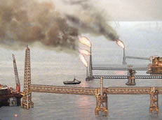
Oil rigs burning off (Smith Mexican Air Force)
Is it possible?
by Tim Printy © August 2004
Updated January 2005
Arguments for oil well fires
Captain Franz has an excellent website that clearly shows how the azimuth readings in the video point directly towards the oil well field. Additionally, the works of Laurent Leger and James Smith featured add to the case for oil well fires. To further verify the situation, I tried to determine how far the objects in video were from the aircraft.
The video tape gives us some good information. However, there are problems with the data. The aircraft's position is only updated every five seconds. Even then, the position is only updated to the nearest hundredth of a minute of arc. This sounds precise but this only gives a resolution of about 60 feet. Because of this and the five second update, the aircraft appears to move in a zig-zag pattern if one plots the positions. The aircraft is not actually moving in a zig-zag and it is likely that it was more like an "S", with gradual changes in direction and not instantaneous changes. Additionally, the azimuth bearing is in relation to the aircraft and not true north. Figuring out which direction the camera was pointing can be difficult especially when one considers the problem that the azimuth readings do not instantaneously change and after rapid movement of the camera, the readings take some time to "catch up". This appears to be due to "slop" in the encoders/mechanism.
In order to try and get somewhat accurate measurements, I decided to interpolate the position values between five second updates. Additionally, in order to try and make sense of the aircraft's heading without making instantaneous changes in direction, I interpolated the changes in heading between each update. The difference between the two methods, while not the same, is not significant when it comes to getting reasonably accurate distance calculations.
This method of correcting with the plane's heading can be considered suspect in that the display only reads out two decimal places, which equates to a resolution of 0.6 seconds of arc (about 60 feet for this longitude/latitude). If the value displayed is off by +/- 0.004 minutes of arc (the maximum error that would still indicate the same value in hundredths of a minute of arc), an error of about +/- 1 degree is introduced (depending on the changes in longitude/latitude). More accurate calculations could be made if the aircraft data were available but this seems unlikely.
With these considerations, I attempted some rough distance calculations for some of the objects in the video.
The first objects I tried to determine the distance on were the first trio of lights seen in the grouping of 11-14 objects between 17:04:14 and 17:07:20.
At time 17:04:14, the first trio of lights are about -134.8
At time 17:07:18, the first trio of lights are about -139.2
Since the position in the video only updates every five seconds, one has to interpolate the rough position of the plane based on the position before and after. This computes to (based on lat and longitude changes) 11.23 miles.
The azimuth values are based on the plane's heading. Looking at the longitude and latitude before and after this point we can compute the actual plane's heading using vectors.
| Time | Long | Lat | Aircraft bearing |
| 17:04:06 | 90º44.87' | 18º26.76' | |
| 17:04:11 | 90º44.58' | 18º26.80' | 82.1° |
| 17:04:14 | 90º44.41' | 18º26.83' | 81.0° |
| 17:04:16 | 90º44.29' | 18º26.85' | 80.2° |
| 17:07:11 | 90º34.40' | 18º28.37' | |
| 17:07:16 | 90º34.15' | 18º28.41' | 80.9° |
| 17:07:18 | 90º34.26' | 18º28.43' | 81.3° |
| 17:07:21 | 90º33.87' | 18º28.45' | 81.9° |
table 1 - Computing corrections for planes bearing (trios)
The net heading between 17:04:14 and 17:07:18 was 81.0 degrees. As a result, we receive a 0 degree heading correction for 17:04:14 and +0.3 degree for 17:07:18. This creates a corrected azimuths of -134.8 and -138.9.
Using these values, one can create a basic triangle to determine the distances. The base is 11.23 miles with the opposing angle is 4.1 degrees (139.4-138.4).
We also know that the first angle is 134.8 degrees and the second angle is 41.1 degrees (180-138.9).
This makes the distance at time 17:04:14 = (Sin 41.1*11.23 )/Sin 4.1= 103.25 miles
This makes the distance at time 17:07:12 = (Sin 134.8*11.23)/Sin 4.1= 111.45 miles
I also entered a few more values at other times in the video.
| Time | Lon | Lat | brng | Distance traveled | Headng | O/A Dir | final brng | Distance |
| 17:05:46 | 90º39.26' | 18º27.67' | -137.9 | 5.70 miles | 80.9 | 80.7 | -137.7 | 79.94 miles |
| 17:06:36 | 90º36.42' | 18º28.08' | -138.7 | 8.84 miles | 82.1 | 81.1 | -137.7 | 123.98 miles |
| 17:06:48 | 90º35.72' | 18º28.18' | -139.0 | 9.61 miles | 82.1 | 81.2 | -138.1 | 118.46 miles |
| 17:07:04 | 90º34.81' | 18º28.31' | -139.2 | 10.62 miles | 82.1 | 81.2 | -138.3 | 123.44 miles |
table 2 - parallax calculations for "trio" distances
The 17:05:46 time tag observation is interesting in that it does not closely agree with the values calculated at all the other positions. If one recognizes the problems associated with getting accurate values, I would not consider this too significant an error. All of the values seem to agree that the lights were fixed and very distant (80-120 miles).
Interestingly, the latitude and longitude for the oil wells (according to Capt Franz site) in this direction are:
| Oil well | Longitude | Latitude |
| AKAL-C | 92º02'20" | 19°23'57" |
| AKAL-J | 92º04'31" | 19º25'41" |
| NOHOCH-A | 92º00'14" | 19º22'06" |
| NEPTUNO | 92º02'00" | 19º26'00" |
table 3 - oil well transponder locations
Using the latitude and longitude for the plane one can compute the distance (http://www.wcrl.ars.usda.gov/cec/java/lat-long.htm):
| Time | Longitude | Latitude | AKAL-C | AKAL-J | NOHOCH-A | NEPTUNO |
| 17:03:31 | 90° 46.80' | 18° 26.43' | 105.6 miles | 108.7 miles | 102.5 miles | 106.8 miles |
| 17:04:11 | 90º 44.58' | 18° 26.80' | 107.2 miles | 110.3 miles | 104.1 miles | 108.4 miles |
| 17:05:16 | 90º 40.95' | 18° 27.42' | 109.9 miles | 113.0 miles | 106.8 miles | 111.0 miles |
| 17:06:36 | 90º 36.42' | 18º 28.08' | 113.5 miles | 116.6 miles | 110.4 miles | 114.5 miles |
| 17:07:16 | 90º 34.15' | 18º 28.41' | 115.3 miles | 118.4 miles | 112.2 miles | 116.3 miles |
table 4 - distances from airplanes positions to oil wells
This check of the latitude/longitude seem to closely agree with the values I calculated using azimuth values and distance traveled by the plane. If the lights in the video are fixed objects as they appear to be, then these calculations tend to confirm that the oil well fires were the cause of the images in the video.
As another check I did the same measurements with the two lights dubbed "The Twins" with the following information:
At time 17:03:36 azimuth -133.4
At time 17:05:17 azimuth -135.6
The plane's bearing computes to:
| Time | Long | Lat | Aircraft bearing |
| 17:03:35 | 90º46.80' | 18º26.43' | |
| 17:03:36 | 90º46.51' | 18º26.47' | 82.1° |
| 17:05:11 | 90º41.24' | 18º27.38' | |
| 17:05:16 | 90º40.95' | 18º27.42' | 82.1° |
| 17:05:17 | 90º40.83' | 18º27.44' | 82.1° |
| 17:05:21 | 90º40.66' | 18º27.46' | 82.1° |
table 5 - Computing corrections for planes bearing (twins)
In this case the bearing appears very constant meaning any heading change was insignificant. However, the overall bearing is 80.3 degrees. Since the headings are the same, the corrections are equal (1.8 degrees). The corrected azimuths are 131.6 and 133.8 but the difference remains 2.2 degrees.
The distances compute to
17:03:36 = (Sin 47.2 * 6.30)/Sin 2.2 = 120.42 miles
17:05:17 = (Sin 131.6 * 6.30)/Sin 2.2 = 122.72 miles
I attempted a few other measurements of the "Twins" at different times.
| Time | Lon | Lat | brng | Distance traveled | Hdng | O/A Dir | final brng | Distance |
| 17:03:46 | 90º46.02' | 18º26.56' | -133.6 | 0.54 miles | 80.9 | 79.6 | -132.3 | 33.05 miles |
| 17:03:56 | 90º45.44' | 18º26.64' | -132.8 | 1.18 miles | 80.9 | 81.0 | -132.9 | 38.89 miles |
table 6 - parallax calculations for "twins" distances
The differences in distances are interesting and the 17:03:36 or 17:05:17 measurement may have been in error giving the false impression of great distance. If one computes the distance from these two time tags in the table, the distance computes to about 45 miles. Considering the angular size of the "Twins" in the video one could reason that these were much closer than those images of the "trios".
So if the Twins are not related to the oil wells listed in table 3, what were they? It is hard to say but about 50-60 miles distant from the airplane's position are a few token oil wells northeast of Ciudad del Carmen close to the coast. There could also be something near or on the coast (such as the cooling towers of a power plant), which is what the calculated distances indicate. In the video shot by Captain Franz in his aircraft, there are a pair of bright oil well fires visible that could be the "twins". In my discussions with James Smith, he noted that with such a small distance traveled between 17:03:36-17:03:56, any small variation in angle (which could include the resolution problems I described earlier) produces a large change in distance. Therefore, it seems possible these two time tags are too close to the first point, which amplifies the errors inherent in the measurements. Without further information, it is hard to determine exactly what is being seen and which distance calculations are the most accurate. The only conclusion one can draw is that the "twins" are tens of miles away from the aircraft and could be in the vicinity of the AKAL oil well complex.
A review of James Smith's work points toward the Neptuno oil well platform (he calls them the M and G flares), which lies within about a degree of where the FLIR was pointing. Dr. Bruce Maccabee points out that the Azimuth reading could have an error of up to one degree, which can account for the difference. Looking at the medium angle image at 17:03:36, one can see the AKAL complex lights about 1.3 degrees to the left as a small grouping of lights. This is about the angular spacing one would expect between AKAL-J and Neptuno so it is possible the "twins" may be the two flares, M (W92º01'56" +19º25'50.6") and G (W92º03'5.2" +19º26'36.5"), on or near the Neptuno platform (W92º02'00" +19º26'00"). However, one can not definitely state this is the case. The intensity of the lights might be explained by James Smith, who states, "that smoke, haze, water vapor, clouds or moisture are diminishing the string flares, while a clear view to M and G is available. The other possibility is that M and G are enhanced due to some thermal distortion. A less probable possibility is that these two flares are burning off at much higher rates" (Smith Mexican UFO). One could also suggest they are brighter because they are closer. However, Infrared expert John Miller told Robert Shaeffer that brightness of the image does not necessarily imply an object that is closer. More information is needed to accurately determine if these oil well flares are the "twins". I stll profess that this is one mystery that has not been reasonably solved at this point (although Smith's effort appears to point towards the likely source).
What bothers me most is how much of this information had been available to many UFOlogists shortly after the video had gone public but not one person (other than Franz) has bothered to publicly announce on UFO updates that there is a pretty good amount of data that supports the oil well fire hypothesis. Captain Franz stated, "There is no doubt about this finding and I am surprised to see that some experienced investigators have failed to find out this compelling information"(Franz). Apparently, nobody wanted to suggest that the UFOs were "flying oil wells".
Works Cited
Franz, Alejandro. Mexican Air Force FLIR images are oil well flames! Available WWW: http://www.alcione.org/FRAUDES/FAM/FLIR_CONCLUSION.html
Smith, James. Mexican UFO Video 2004 analysis. Available WWW: http://home.earthlink.net/~bigvideo4/mexican_ufo.html
-. The Mexican Air Force UFO Affair: Aliens, Ball Lightning, or Flares? E-skeptic newsletter July 24, 2004. Available WWW: http://www.skeptic.com/eskeptic/04-07-24.html
NEXT: Oil wells don't move with respect to each other, do they?
Back to My skeptical opinion about UFOs