Radar contacts
by Tim Printy © August 2004
Updated October 2004
The other half of the Mexican UFOs (2004 edition) equation are the strange radar contacts reported by the Radar operator on the airplane. The radar in use at the time was an APS-143(V) "Ocean Eye"™ (some sources stated this was the B(V) version). This radar was designed for maritime surveillance of surface targets but could be used to track aircraft.
Already known is that almost all the FLIR images did not show up on radar with the exception of the very first one around time 16:58. Other radar images seem to be interesting but they were very slow. A basic summary from the transcript of the FLIR video made by Patricio Elicer on the James Randi discussion forum shows us the following described radar contacts (times are approximate based on what I could determine from the video tape and Patricio's transcript):
| Time | Relative Bearing | Speed | Distance | Targets heading | Comment |
| 16:42:20 | 330 | 75 | 4 | 297 | Aircraft bearing was 303 194KT |
| 16:42:53 | 360 | 75 | 2.9 | ||
| 16:43:10 | 65 | 2.1 | |||
| 16:43:34 | 97 | 2.14 | |||
| 16:44:00 | 113 | 298 | |||
| 16:44:00 | 213-285 | ||||
| 16:44:30 | 194 | ||||
| 16:44:52 | 360 | 177 | 2.1 | 300 | |
| 16:45:05 | 360 | 206 | 301 | ||
| 16:46:42 | 207 | 2.1 | 302 | Plane turns about 16:52 to course 81 | |
| 16:53:09 | 210 | 334 | 10.5 | 283 | Aircraft bearing was 81 196KT |
| 16:55:44 | 31.8 | 16:57:20 lost by radar | |||
| 17:15:07 | 270 | ||||
| 17:15:57 | 30 | 52 | 19 | ||
| 17:16:20 | 30 | 52 | 17.1 | 95 | |
| 17:17:04 | 30 | 52 | 14.8 | 99 | |
| 17:18:15 | 30 | 52 | 10 | ||
| 17:18:53 | 60 | 52 | 9 | 120 | |
| 17:19:46 | 90 | 52 | 6.9 | 155 | |
| 17:21:07 | 90 | 52 | 7.1 | 182 |
table 11 - Transcript related radar contacts.
Numbers in red are corrections suggested by Patricio Elicer, whom I am grateful for in assisting me. I then adjusted the times again to Captain Franz's transcript.
The initial contact at 16:42:20 seems somewhat ordinary in that it is traveling at a very low speed and could easily be a small civilian aircraft flying about 60-90 knots. There is nothing unusual except that it can not be located visually.
At time 16:44, things change for this contact in that it suddenly speeds up to about the same speed as the C-26A (which according to Laurent Leger's map was 194 knots). It is interesting during this time period the contact oscillates in speed around that of the C-26A and is at a bearing that was straight ahead. The FLIR failed to detect this target. Considering the distance during this time period was about the same (2.1NM) and does not change, it implies that the crew may have been chasing some form of radar ghost/reflection of their own aircraft.
However, Brad Sparks disagrees at this conclusion. He states:
For more than 1 minute from about 4:45 to 4:46 PM the FLIR camera was viewing at WIDE angle straight ahead of the plane where the radar target was tracked heading away from the aircraft at exactly the same heading as the Mexican AF plane to within a degree (301-302 degs True), traveling at almost exactly the same speed (237 mph versus the Mexican AF's 227 mph) and this time (at 4:45:10) a possible unidentified FLIR image or "light" was picked up and tracked intermittently for the next few minutes. This may be the one correlation between FLIR and radar data in the entire incident, though unfortunately because of incompleteness and lack of precision of the radar data and gaps in the FLIR tape there is regrettable uncertainty. (Sparks Re: Oil)
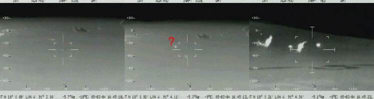
Looking at the video, I did see a bright light around time 16:45:13 show up in the clip that was intermittent. However, when this area was examined by the crew at time 16:45:20-29 using the medium FOV (which should have included the target identified in the wide view), it appears that the target was a ground source or maybe a cloud as one can see below:
Possible Brad Sparks radar target (marked with "?") and later medium FOV examination of the area.Frame grabs using "Snatch-it" and video taken from video located at Thomas Strunch's webpage http://www.pixcells.dk/mexico/mexicoDODstream.wmv
This same area was checked again at time 16:46:30 and pretty much showed the same ground source. In the frame of 16:45:12, the targets just below center were also checked at time 16:45:07 and showed only two ground sources. I am not sure what Sparks is referring to in these frames but it appears there are no contacts that can match the radar target.
At time 16:52, the C-26A shifted its course from a Northwest track towards the east. At this point a point of light at bearing -136.4 is identified and is supposed to be the same contact identified by radar at this time. However, the bearings don't seem to match up with the radar contact
| Time | Lon | Lat | Bearing | Heading |
| 16:53:03 | 91°21.45' | 18°22.73' | -136.4 | 90 |
| 16:53:27 | 91°20.21' | 18°22.64' | -135.0 | 97.9 |
table 12 - Bearing towards the FLIR contact visible at the time of the radar contact
Notice that the bearing is moving ahead towards the aircraft, which is not what one would expect from a stationary object. Therefore, this appears to be moving but it is not the target on the radar. The radar contact is moving at a high speed (334kts) towards bearing 283 and only a little over ten miles away. This means the contact would move towards -180 degrees at a high angular rate (If the plane were stationary, the object would move roughly 12-13 degrees in 24 seconds!) and not towards 0 degrees as the object in the FLIR does. This makes any connection between the radar contact and the FLIR target completely invalid.
This does not explain the motion of the radar contact. One can only assume that this contact is some other aircraft or, possibly a stationary target roughly 40 miles away. It is interesting to note that the speed of the target did not "jump" to 334 knots until after the aircraft had made it's turn towards the east. Perhaps the report that the radar contact moves away from the aircraft at a speed of roughly 334 knots (about 140 knots above the speed of the aircraft) gives reason to consider this possibility.
After this short clip, the time tag suddenly jumps to 16:55:22, where a solitary blip is visible. This does not appear to be the same radar contact as 16:53 as it's bearing is relatively constant (-132.3 at 16:55:22 and -133.4 at 16:57:42). This seems consistent with a more distant stationary object than a fast moving radar contact. Leger's bearings point toward the oil well Abkatum C at this moment in time. Again, there is no relation of this FLIR image with a radar contact.
The last part of the transcript describes a radar contact that is moving at an extremely slow speed of 52 knots. Despite the contacts slow speed, they are unable to locate it with FLIR. The closure rate seems consistent with the two objects relative speeds, therefore it seems likely that this was an actual contact. However, the contact may have been more earthly as Brad Sparks points out:
Thanks to a new map plotted by Dr. Bruce Maccabee I can follow up on my suggestion yesterday that some but not all of the radar targets that were tracked may have been trucks or vehicles traveling 60 mph (52 knots) down Yucatan roads. In fact from 1715 to 1718 (CST) on March 5, 2004, there were one or more such radar targets and they actually match the headings of the roughly west-east Yucatan Highway 186 that the Mexican AF C-26A aircraft flew over at 1718 The aircraft was heading almost due East, toward heading 81 degs True, when the voice transcript shows the radar operator reporting at about 1715 a radar target off to their right front at about 1 o'clock position, 19 nautical miles away, traveling 52 knots (60 mph). The target maintained that speed and approximate 1 o'clock position from the aircraft but the aircraft closed in on it reducing the distance - at about the exact rate one would expect from a 200-knot speed of the aircraft....In fact, at about that approximate distance away from the aircraft at that time interval the Highway 186 curves slightly more eastward from about a 110 deg heading to about a 95-deg heading, on the stretch between and just past halfway point from Francisco Escarcega (Es Carcega on other maps) and Xpujil. The radar target was plotted at a 99-deg heading at about 1717 (the exact times are subject to maybe 1 minute of uncertainty because they are not keyed to timings to the second on specific statements). The headings are a virtually exact match, if not an absolutely exact match depending on where the truck or vehicle on the road may have been located. If the truck or vehicle was on the slight eastward bend on the road at the time it was radar tracked as heading 99 degs then the road might indeed have been curved at exactly 99 degs along that stretch. How much instrument error one can expect on heading calculations on the APS-143 radar is not known...To sum up from this and previous posts: Some, but not all, of the Mexican radar targets seem to be vehicle traffic on Yucatan Highway 186. Some of the FLIR infrared images or "lights" as I previously posted, may possibly be sun reflections off of distant satellites in Molniya-type orbits (what I call the Group 2 images), satellites in medium-high polar orbits (Group 3 FLIR images though a question might be raised as to feasibility of extended duration of reflections from such faster-moving satellites), and geostationary satellites (Group 4 images). All of these Group 2, 3 and 4 FLIR images are above the earth's horizon line according to the FLIR system data,.and in some cases the actual horizon line can be seen, according to Maccabee. What I call the Group 1 infrared images are the only ones in the right direction and occurring below earth horizon as to possibly be due to oil fire burnoff of the Cantarell oil fields as first suggested by Capt. Franz (but Cantarell cannot explain all the other FLIR images as Franz seems to think). Some radar and FLIR targets remain anomalous. (Sparks Radar)
While I do not agree with Sparks assessment of the rest of the video, I am in agreement with this possibility. My map did not quite match what he describes but I have not precisely plotted the aircraft's position. The idea that a truck or large vehicle could have produced this radar contact is something that has to be considered. Recall that this radar was designed to track surface targets as well as air. The radar operator did not seem able to identify altitudes meaning this information was unavailable or the operator was not skilled in doing so. Perhaps he was only recognizing radar targets on his screen and was unable to determine if they were airborne or simply on the ground. If this were the case, then the radar contacts are not so mysterious after all.
The radar contact portion of this case seems to have probable "earthly" explanations and there seems to be no FLIR/Radar contact matchups.
Works Cited
Sparks, Brad."Radar Targets May Be Trucks On Yucatan Highway" 31 May 2004.UFO Updates Mailing list. On line posting. Available WWW: http://www.virtuallystrange.net/ufo/updates/2004/jun/m01-002.shtml
-. "Oil wells objectively investigated" 17 June 2004. UFO Updates Mailing list. On line posting. Available WWW: http://www.virtuallystrange.net/ufo/updates/2004/jun/m17-020.shtml
NEXT: UFOs over Mexico 2004 solved?
Back to My skeptical opinion about UFOs