In late September 2002, David Rudiak, in conjunction with Brad Sparks, presented a web page that was meant to deliver a mortal blow to the NYU flight#4 hypothesis for Roswell. What good points that were raised for discussion were quickly overshadowed by a vicious attack on Professor Charles Moore's integrity. Rudiak, who was unable to arrive at the same conclusions as Moore, accused Moore of "cooking the books" to reach his predetermined conclusions. Is Rudiak correct that the Professor is a hoaxer/liar? These types of accusations need substantial proof to determine if they are accurate or not.
Rudiak has long been an opponent of Professor Moore because of his role in supporting the flight #4 theory that explained the Roswell incident. Being a pro-crashed spaceship advocate, Rudiak has continuously launched numerous arguments for his case against flight #4. Many of these arguments were weak, subjective, or wrong. However, in this recent diatribe, Rudiak has convinced himself that Professor Moore is not only a debunker but also a hoaxer and has openly declared,
I think he is obviously also willing to cook his story when it suits his purposes, namely to advance his pet theory that his lost Mogul explains Roswell. I think he should be condemned in the strongest terms for his hoax, which just serves to further muddy the waters. (Rudiak Re: New)
I guess the question is "who" should condemn Professor Moore and for what reasons? Is Rudiak referring to the scientific community? If so, he should choose the correct forum to present his accusations. I am sure his article will have no problem appearing in the MUFON journal and International UFO reporter. But will it have any chance of showing up in the Journal for Atmospheric Sciences? Rudiak's work needs to justify his incriminations.
Rudiak initially announced his latest broadside against Moore on the popular Internet forum, UFO Updates (http://minus.com/mlV3acTFC). Interestingly, an initiative has recently gained ground among some of the members calling for Peer Review of investigative reports, primarily to avoid errors and increase credibility. If Rudiak had submitted this research for peer review, a careful examination of his analysis might have revealed many of his errors before it was published. Unfortunately, despite the initiative, most of the members of the UFO Updates List do not seem interested in examining Rudiak's data or questioning his conclusions- a vital part of the Peer Review process. Instead there was unquestioning, willing acceptance of the work as is. Two posts to the List shortly thereafter made it obvious that there would be little "peer review". Dr. Bruce Maccabee (a scientist who should have known better) merely stated, "Thanks for your exhaustive... and exhausting... analysis!" (Maccabee). Even more interesting were Robert Gates comments,
Bottom line is to have Roswell/mogel in perspective you have at the very, very best a theory that is 17 miles short and from what you have uncovered a theory that was bogus and hodge podged together to come up with a set of facts. (Gates)
So, Rudiak was given a "free pass" from the primary discussion board on UFOs populated by many of UFOlogy's brightest individuals. However, does this make him right?
My stance
Before I start, let me make it clear that I have long felt that the flight #4 explanation is adequate for the debris found at the Foster Ranch by Mack Brazel, so I am immediately placed in a position to defend Moore's work. Since I don't have a degree in atmospheric physics, I can not speak with authority on this subject. However, I will still try and respond to some of Rudiak's accusations in order to hopefully set the record straight. I am aware the Professor Moore only created this model as a way to show how it was possible for flight#4 to get to the Foster Ranch. There are many variables that can affect the flight and throw things forward or backward a few miles. The important thing to recognize is that the winds appear to have been favorable enough to place the flight in the vicinity of the Foster ranch. Because nobody else reported finding the remains of the flight, the report by Brazel indicates that Foster Ranch is where the flight landed.
Rudiak's less than accurate representation of data
Rudiak relies on the fact that Moore's book and the 1994 AF report are not widely available to the reader and therefore, they must accept HIS representations as accurate (Note: Those who want to read the full 1994 AF report and not just the summary, should go to the Wright Air Development Center Digital collection at http://contrails.iit.edu/history/roswell/). A wonderful example of how he misrepresents things is how he describes Moore's assumptions and spins them to suggest he meant another thing,
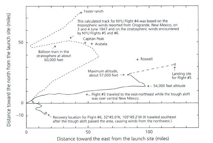
Because the Orogrande wind data only extended to 46,000 feet, Moore interpolated winds from the successful Flight #5 the next day (June 5). Moore stated that he was modeling Flight #4 after #5, even assuming that #4 was a more successful flight. (Rudiak Phony)
He states this because of Moore's statement, "I think that Flight #4 used our best equipment and probably performed as well as or better than Flight #5" (Benson, Saler and Moore 102). Rudiak interprets this to mean that the flight #4 had to follow an atmospheric model similar to flight #5. This is not the case, and the truth is in front of his nose. Moore modeled performance of flight #4 from the data obtained from flights 5 and 6. This is clearly labeled on figure 6:
This calculated track for NYU Flight #4 was based on the tropospheric winds reported from Orogrande, New Mexico, on 3 and 4 June 1947 and on the stratospheric winds encountered by NY Flights #5 and #6. (Benson, Saler and Moore 102)
Rudiak is reading what he wants to read and not what is stated, and deliberately misleads the reader to accept his corrupted version of Moore's facts.
Another example happens to be his representations of flight #5 in his time-altitude plots. He states that the data presented is from Mogul flights 5, 6, and 7 (actually these are NYU service flights not MOGUL flights - a minor point). However, his plot for flight #5 is NOT an accurate representation of flight #5. The way Rudiak plots it, makes one THINK this is the actual data. The actual flight #5 has two separate plots running between times 100 and 260 minutes. Looking at Rudiak's graphic, we see only one plot running from 100-260 minutes. The reason for the two plots is because, as listed on the NYU Report graphic, "Data subject to interpretation due to lack of recorders" (HQ USAF Attachment 32/Appendix 13/Figure 33).
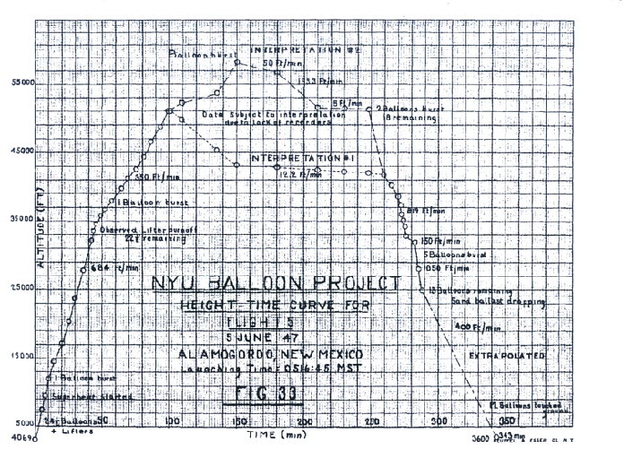
FIGURE 33 from the NYU report
Moore addressed this in his book but Rudiak gives the reader a selective version of what Moore said:
Moore also declared that he thought in retrospect, the original plotting in Mogul records of #5's altitude to be flawed. He revised the track of #5 in the stratosphere (above about 52,000 feet) such that it rose smoothly until some of the balloons started breaking and the balloon train started to descend (compare the yellow plot from Mogul records with Moore's revised plot in black). (Rudiak Phony)
This makes it appear that Moore was doctoring the books, which is exactly what Rudiak wants everyone to believe. However, he never bothers to explain fully why Moore revised the plot. In explaining his revision, Moore stated:
The atmospheric pressure information from which the altitudes were calculated for Flight #5 was obtained by the manual recording of the changes in the audio signal telemetered from the radiosonde...Problems with this technique developed in our constant-level flights because radiosondes were designed originally for use on ascending balloons only. Ambiguities arose when a balloon leveled off and then started a descent. If more than four humidity switchings occurred between reference signals, the observer on the ground could not know whether the balloon was ascending, descending, or oscillating in altitude when the next reference signal was received. Furthermore, because we had not been allowed to bring to Alamogordo our heavy but useful recorder for the radiosonde signals, we had difficulties in keeping track of the switchings, so that errors both in recording and in the subsequent analysis were possible. Because of the uncertainties in the manual record, two different interpretations (which I refer to interpretations 1 and 2) of the altitude information were presented n NYU figure 33. As is discussed below, with hindsight and experiences gained in many subsequent flights, I now think that a different interpretations (interpretation 3), shown in Figure 1, is more likely for the Flight #5 time-altitude information...To verify its worth, I have examined possible ground tracks that would result from the use of the greater altitudes suggested in the midportions of interpretation 3 with the reconstructed theodolite elevation angles extracted from interpretations 1 and 2. Both of these sets of data would place the balloons, while still at their maximum altitude, almost directly over the spot where they later landed. With such a location over the recovery site at the start of the final descent, no further displacement to the east could have occurred during the final descent, despite the strong tropospheric winds observed during the ascent. Such a cessation of winds aloft was unlikely, but the ground track shown in NYU Figure 32, and here in Figure 2, is consistent with the actual recovery site, about 25 miles (40 km) east of Roswell. That location is certain because the B-17 pilot followed the balloon train until it descended to Earth, just east of an oil derrick where drilling operations were in progress... (Saler, Ziegler and Moore 86-8)
Moore lays a good case for creating his plots, but Rudiak deliberately ignores most of it, leaving the reader only with Rudiak's conclusion without the appropriate explanation.
Rudiak then takes aim at Moore's representation of flight #6:
Moore also changed the original plot for Flight #6, altering azimuths and altitudes to get the crash location to square with the trajectory plot. Although these manipulations are questionable, at least Moore was direct in stating what he had done. (Rudiak How)
While David did at least mention that Moore had explained his reasons and his methods for refining the data, Rudiak fails to show them- again leaving the reader with the false impression that Moore had performed some devious chicanery. Here are Moore's reasons:
If the ground track were correct and errors were made in reporting the recovery site, the actual site would have been deeper in the mountains, in an area almost inaccessible from High Rolls, where Sid West, who recovered the equipment, resided. However, there was a road directly south from High Rolls that passed near the location where West reported having recovered the debris from this flight...On examining the track, I noted that all of the azimuths appeared to be rotated clockwise about 12° or 13° , suggesting that perhaps someone made an unnecessary correction to the original azimuths measured during the flight. The magnetic declination for Alamogordo at that time was about 12.5° . It appears to me that someone in the NYU data reduction section may have added the magnetic declination to the azimuths reported for the theodolite measurements when the analyst learned that the theodolite orientation was made using a compass but he or she did not know that this correction had already been made. In any event, replotting the ground track data after subtracting the 12.5° from the azimuth for each location rotates the track counterclockwise so that the last point of the track is almost on the azimuth of the reported recovery site. However, the last point is about 20 percent more distant than the launch site than is the recovery site. But the maximum altitude of 72,500 feet (22.1km) given in NYU Figure 35 is about 20 percent greater than the peak altitude of about 60,000 feet (18 km) given in Crary's diary for this flight. Figure 3 in this chapter was prepared by use of the corrected azimuths and by scaling the horizontal distances by the factor (60,000-4069)/(72500 - 4069), where 4,069 is the altitude in feet of the theodolite at Alamogordo. With these corrections to the Flight #6 ground track, the last point on the new ground track lies just upwind (i.e., southwest) of the probable actual recovery site...I think the revised plot is probably more nearly correct than the one given in NYU Figure 34. The origin of the altitude error in plotting is not clear; Crary obviously obtained his value for the maximum altitude from us, because we received the radiosonde signals during the flight, but for some unknown reason, the NYU data analysts chose a different interpretations, one that now seems unlikely... (Saler, Ziegler and Moore 94-5)
I am not sure what Rudiak means by questionable but without giving Moore's explanation for the adjustment, he is trying to paint Moore in a certain light that is being less than honest.
In the dark of the night
In evaluating the data for flight #4, Rudiak starts right off with Moore's time of launch. He states:
Now here's how Moore tries to finesse this data into a 3:00 AM launch time (p. 102):
"There are, of course, many uncertainties associated with this analysis of the 4 June events. The launching time is not known, but given that Crary's diary shows that he was ready for the launching soon after midnight on 3 June, and given that the clouds that caused the launch delay went away at around 0230 MST on 4 June, I am sure that we would have launched as rapidly as possible thereafter."
First of all, Crary's diary does not say they were up "soon after midnight" on June 3. He said they were "up at 2:30 AM." [Note how Moore tries to spin this to push times back by about 2 hours.] (Rudiak Phony)
Rudiak appears to be confusing the dates. Moore seems to be referring to midnight 3/4 June and Rudiak pins it to the entry of midnight 2/3 June. The actual 4 June entry reads:
Jun 4 Wed. Out to Tularosa Range and fired charges between 00 and 06 this am. No balloon flights again on account of clouds. Flew regular sonobuoy up in cluster of balloons and had good luck on receiver on ground but poor on plane. Out with Thompson pm. Shot charges from 1800 to 2400. (HQ USAF Attachment 32/Appendix 17)
Note that he was up at 0000 to fire charges. Also important is the journal entry for June 2, where Crary remarked "Changed shooting plans to coordinate with balloon flights"(HQ USAF Attachment 32/Appendix 17). Therefore the 0000 shots were apparently meant to coincide with a balloon launch. Rudiak does not address this because he was either ignorant of this entry or chose not to present this piece of information that might indicate a flight was planned for midnight as Moore has suggested.
Clouds or clearing?
Rudiak next mentions the weather, and how it could not have cleared by 3AM at Alamogordo. According to Rudiak he refers to the data showing the clouds clearing at Columbus (about 130 mi SW of Alamogordo) between 11 and 2 AM. Rudiak suggests that the clouds in Columbus moved towards Alamogordo at speeds of about 40-50 mph and therefore would not show any clearing until around 5AM. Unfortunately, the time of actual clearing for Columbus is not known. El Paso cleared around 2:30 AM and it was only about 80 miles to the SSW of Alamogordo and about 70 miles east of Columbus. Engle, only 50 miles to the NNW, also cleared around 2:30 AM. Rudiak never addresses how Engle and El Paso could clear so fast when it was supposed to be cloudy in Alamogordo until 5AM. It seems that the cloud cover was not only moving but dissipating out as atmospheric conditions changed. Since Engle had cleared by 2:30 AM, Moore apparently reasoned that similar conditions had occurred at Alamogordo around 3AM and they quickly launched the flight that had been readied for the 0000 launch to coincide with the charges being set off.
There are many remarks in the NYU records about difficulty in launching these flights. If they had been ready at midnight, as suggested by the Crary Journal entry, they would have launched once they felt conditions were adequate. The planning of an early launch time implies that radar reflectors were used since it would be difficult to track the balloons in the dark (even though there was a nearly full moon) with a theodolite. Additionally, if radar reflectors were in use for tracking, this would explain for the lack of any need to be too concerned about the theodolites losing sight of the flight if they passed through some scattered clouds, and means that it could have been possible to conduct the launch under less than desirable conditions (such as some mid-level clouds that showed signs of clearing). Could it have been clear enough around the time of launch? There seems to be that possibility despite the protestations of Rudiak.
Rocketing balloons and death dives
Rudiak's discussion of flight #4's performance now dismisses the one line that he quoted from Moore's book about it using better equipment and performing better than flight #5. He launches an assault on the rate of rise for Flight #4 being greater than Flight #5. This is correct to a certain point. Flight #5 actually had a faster rise rate than flight #4 (684 ft/min vs 600 ft/min) up to 35,000 feet. However, after this point, three lifter balloons cut away and the rate of rise dropped to half the original rate. Flight #4 does not do this, and Rudiak recognizes it. He states, "This would only have happened if there had been equipment malfunction, contrary to Moore's stated assumption that #4 used their best equipment and was at least as good as #5" (Rudiak Phony). Rudiak is correct but he does not even mention some glaring issues that hindered Flight #5's ascent. According to Moore, flight #4 contained 3 radar reflectors, which totaled in weight less than 300 grams. However, flight #5 did not use the reflectors. It used a radiosonde instead. The transmitter and additional battery packs in use would have produced a significant additional weight that, while compensated for in the initial lifting gas calculations, could have had an effect during the ascent.
Recall that these were early flights and there were problems with getting the techniques down and the theory-to-practice had not been worked out yet. Examining flight #5's time-altitude plot, one can see they did not get the amount of lifting gas right again as the initial lift (793 ft/min) was far greater than that desired (600ft/min). It can be assumed that they used a similar calculation for flight #4, which would have given a greater amount of lift than expected for the weight. As a result it can be assumed the initial ascent rate used by Moore is less than it should be.
Also not mentioned by Rudiak is that Flight #5 had two balloons burst on the way up to the stratosphere. Below is a table derived from flight #5 showing the effects of these bursting balloons (altitudes are approximate to within a few hundred feet due to the scale of the graph). The obvious conclusion is that Flight #5 would have risen far faster, even with the extra weight, had it not prematurely lost some balloons. This is what Moore means when he felt that they used their best equipment and had the best performance.
| Time (min) | Altitude (ft) | Rate of rise | Remarks |
| 0 | 4069 | 0 | Launch |
| 10 | 12000 | 793.1 ft/min | 1 balloon burst at this altitude |
| 20 | 17400 | 540 ft/min | |
| 30 | 23800 | 640 ft/min | |
| 40 | 30500 | 670 ft/min | |
| 44 | 33500 | 750 ft/min | Lifter balloons cutoff |
| 50 | 36200 | 450 ft/min | |
| 57 | 38000 | 257.1 ft/min | 1 balloon burst at this altitude |
| 60 | 38600 | 200 ft/min | |
| 70 | 41400 | 240 ft/min |
Effects of balloon bursts on rate of rise for flight #5 (from figure 33 of NYU technical report #1)
Professor Moore's track for Flight #4 assumes that all the balloons were intact on the way up and therefore should have maintained its lift even after the lifter balloons had cut away. Because of the hour of launch time, there was no superheat early on but this was a minor effect on lift (NYU records indicate a 4.7% increase in lift from superheat)( October 19, 2002: This statement is incorrect. The 4.7% value was for polyethelene balloons and not the neoprene flown with early flights. Examining the flight #5 data, we see the early ascent time, prior to superheat taking effect at ~8 minutes and the balloon bursting was on the order of 667-700 ft/min). Moore's value of 600 ft/min, which is much less than flight #5's initial ascent rate, seems rather conservative in light of this information (October 19, 2002: This statement is true even with the effects of superheat taken into account from flight #5's data). Rudiak DID NOT mention the bursting balloons or additional weight because he does not want anyone to draw a conclusion different than his own. To make certain that he drives this point home he states matter-of-factly:
Like many of Moore's behind-the-scenes manipulations, his fast rise time is subtle and could easily go unnoticed in his tables of numbers (he provides no comparative graphs as I have done which would have made the differences more obvious). (Rudiak Phony)
In writing his section of the book, Moore was probably limited on his space making it difficult to produce all the graphs Rudiak feels that were required. While Rudiak's graphs show some problems, his failing to mention the balloons bursting and weight issue seems to be a "behind-the-scenes manipulation" as well. At least Moore had the courage to present all the data in his tables so anyone could follow his work. Rudiak's failure to produce all the factors affecting the ascent rate can be construed as withholding valuable information to deliberately distort the reason for Moore's values.
Rudiak moves next to the descent phase of flight #4. Moore has a rather rapid descent starting at 300 ft/min at 60,000 feet and accelerating to 900 ft/min by 30,000 ft. Compare this to flight #5, which started with a descent at a rate of 800-1000 ft/min between 40,000 and 25,000 ft (the altitude above 40,000 being open to interpretation as previously stated). Most significant is what happened to the train on flight #5 when five balloons burst around 32,000 feet. At this point the train dropped rapidly (1050 ft/min). The rate only slowed to 400ft/min (which is an extrapolated value) when the remaining ballast was observed dropping. So why did it take so long for flight #5 to make it to the ground and not that long for flight #4?
Looking at the effects of five balloons bursting for #5, we can see a clue. Moore must have figured flight #4's long flight duration had the usual effect on his balloons. Sunlight had started to take its toll on the rubber and by the time the flight had started it's decent, many of flight #4's balloons had probably burst. The evidence for this is in the description Mack Brazel gave concerning the quantity of rubber picked up. It suggested there were only a few balloons that made it to the ground intact. If one figures that some of the upper portions of the train had been taken further away by some balloons as well, we arrive at a number of maybe 6-9 balloons. Compare this to flight 5, which had 12 balloons remaining and flight 6, which had 14 left.
Not too amazingly, Rudiak failed to mention anything about bursting balloons and lift in his analysis. He only compared the average times for the ascent and descent phases without discussing what can affect the descent rates. The uninformed reader again is not given ALL of the pertinent information to draw his or her own conclusion. Worse yet, in his rather blatant attempt to expose Moore's work as false, Rudiak has chosen to ignore/hide important data that might explain the values used. Even worse is that there appears to be no attempt by Rudiak to talk to Professor Moore or an expert on balloons for feedback on these matters. Rudiak resorts to the exact type of "subterfuge" he accuses Moore of doing.
Moore's (or is it Rudiak's) "fuzzy math"
Moore provided pretty detailed tables for his plots in his section of the book, UFO Crash at Roswell: The genesis of a modern myth. These tables included data, which allowed anyone to analyze his work. Because of this openness, Rudiak was able to attempt a recreation of Moore's graphics. However, when he used the data, Rudiak was confronted by a problem:
...I was shocked to discover that the true trajectory given his table data was really the red one. Everything closely agrees during the first leg of the flight, but trouble arose when the trajectory overshot Moore's first turn point by about 10 miles to the NE and at the end overshot Moore's final crash site by about 15 miles to the NE. (Rudiak Phony)
Suddenly, Rudiak sensed he was onto something and then discovered,
...I had to advance the data point by 30 min., cutting short the NE drift by half an hour.
However, even after doing this, Moore's table and graphical trajectories still did not match in the mid-portion and end of flight. I then found that not only did I have to advance one point, I had to advance the next four table wind velocity points. Overall 5 data points between 125 min. and 385 min. (over 4 hours of flight) were pushed forward one notch and replaced data points between 95 min. and 317 min. Everything else stayed the same.
This advancement of the 5 data points is shown in the next graph. Once this was done, the new calculated trajectory (black) closely overlapped what Moore produced in his book (blue). (Rudiak Phony)
Could Moore have made such a drastic mistake? Rudiak felt he had, and presented his conclusion:
While the changing of one data point in his table could have been a simple misprint, the changing of 5 data points is hard to explain away in an innocent manner. Again, it seems to be a very deliberate behind-the-scenes manipulation of data. (Rudiak Phony)
Rudiak's accusations enticed me to attempt this little exercise myself. Surprisingly, my results very closely matched Moore's point for point throughout the plot! Examining Rudiak's curve, even after shifting the five points, I noticed that if you looked at the data points, there wasn't a close match at all. Obviously Rudiak had done something wrong but what? The error can be found by looking at Flight #4's table. Below are some samples:
| Altitude (ft) | Time (min) | Wind speed (mph) | Wind from (deg) |
| 52,000 | 83.4 | 38 | 242 |
| 52,100 | 95.5 | 20 | 242 |
| 53,700 | 125.5 | 17 | 144 |
| 54,500 | 166.8 | 14 | 115 |
Selections from Professor Moore's table in UFO Crash at Roswell: The Genesis of a Modern Myth
Compare this with some selections from flight #5:
| Altitude (ft) | Time (min) | Wind speed (mph) | Wind from (deg) |
| 51,000 | 99 | ||
| 38 | 267 | ||
| 52,200 | 105 | ||
| 17 | 270 | ||
| 53,700 | 135 | ||
| 9 | 144 | ||
| 54,500 | 150 |
Selections from Professor Moore's table in UFO Crash at Roswell: The Genesis of a Modern Myth
The layout of the table for flight #4 is where Rudiak encountered a problem. For flight #5, it is clear that the wind speed and wind direction for the time between the data points is shown BETWEEN the lines. However, for the flight #4 table, one needs to use the speed and direction for the next data point to match Moore's flight path. Therefore, the time between 95.5 and 125.5 would use the 17mph/144 Wind from values.
The table for Flight #4 can be re-stated using the same format as the table for Flight #5 this way:
| Altitude (ft) | Time (min) | Wind speed (mph) | Wind from (deg) |
| 52,000 | 83.4 | ||
| 20 | 242 | ||
| 52,100 | 95.5 | ||
| 17 | 144 | ||
| 53,700 | 125.5 | ||
| 14 | 115 | ||
| 54,500 | 166.8 |
Corrected table for flight #4 to make it easier to understand
When this is done throughout the table, it results in Moore's figure. Rudiak, failed to notice this, or deliberately chose not to tell the reader in order to present the idea that Moore was advancing only selected data points in his table.
Below are graphs showing what happens for the various scenarios (Since I did not have Rudiak's hard data/spreadsheet, the values obtained for his curves are not exactly the same but they are very close. This appears to be due to roundoff error or Rudiak using more points than Moore's table lists):
![[IMAGE]](balloonplots.jpg)
Rudiak's two manipulations of Moore's table and mine compared to Moore's graphic
Note that even when Rudiak got close by shifting five points, his graphic still did not match Moore's, while mine matches each point almost exactly. There was only one data point that did not match. This was the first one. Moore apparently used the 9mph/197 deg value for time 0 instead of the value of 12mph/236 deg at time 2.8min (October 26 2002: Brad Sparks noted that the use of the 197 value does not work and he is correct. In my writing of this webpage, I did not look closely at the values I used on the spread sheet. This should have read that the 9 mph value is substituted for the 12 mph value the X and Y values compute correctly. The wind directions should have been 236 for the first value. I admit this error on my part. Sparks says the use of the 9mph value is incorrect based on the wind vectors. My computations were only for X and Y, which were used to plot the flight path, not the wind speed vectors.). This error carried forward through the table and resulted in the final value being off a tenth of a mile in X and Y. Not a significant error but it also may have led Rudiak to believe he was doing his spreadsheet correctly when it made his first point match Moore's. Rudiak should have recognized something was not right but instead went on a crusade to misrepresent Moore's work. Actually it is Rudiak, who should be embarrassed. He cut short his analysis the instant he "discovered" what he wanted to find.
October 19, 2002: The only section of this web page that David has openly argued against to date is this section stating the math is backward (David resorts to name-calling in his postings demonstrating he is not really interested in a debate on the issues). David misunderstands what I am trying to show here. I was not trying to prove Moore correct but trying to show how Moore computed his values, which Rudiak really did not try to do. Instead he created this "secretly shifting of select points" theory to bolster his claims that Moore was deliberately alterring data behind everyone's back. On this point, he was completely wrong!
The "Secret turn"
Rudiak also had problems with the transition to the stratosphere by flight #4. He recognized that flight #4 made a pretty fast turn towards the NW compared to flight #5:
Instead Moore secretly advanced the turn location to the data point indicated by the red starred * arrow at about 95 minutes into flight. Moore's trajectory doesn't even agree with his own table of data!
Overall, Moore advanced the turn point a full 40 minutes compared to Flight #5 (95 minutes vs. 135 minutes). Not only does this greatly foreshorten the northeast trajectory during ascent, it was also a way Moore secretly tacked on an extra 40 minutes of drift time back to the west on the "front end" of the stratospheric flight. (Rudiak Phony)
Actually, there was no "secret turn" and the table of data agrees with Moore's analysis (October 19,2002: should read "agrees with Moore's methodology"), but Rudiak just failed to figure out the table layout.
However, he has a point when looking at the altitude when this flight made the turn. Moore's flight path for Flight #4 turned just after 52,000 feet, but flight #5 turned after 54,000 feet. Is there a problem with this? There could be, but one has to examine all of the information for flights 5 and 6 to see why Moore may have chosen this value. Moore's reanalysis of flight #6 showed that the balloons were shifting direction after 52,000 feet. This was also the altitude that flight #5 turned (using Rudiak's interpretation #2 graph) during the descent at 247 minutes. Rudiak wants everyone to believe that flight #4 had to perform in the stratosphere exactly like flight #5 but Moore never stated this, as I pointed out before. The "secret turn" is really a matter of Rudiak not being able to understand the layout of the table (something I got on the first try and I don't have a physics degree) and his (deliberate?) misreading of what Moore wrote about the model he used for the stratosphere.
Don't pee on my leg and tell me it's raining!
Rudiak now smelled blood, and there was no longer the pretense of being thorough or clear. We next read:
Moore also quietly raised the stratospheric wind velocities by about 10% over those from Flight #5. Like most of his other assumptions, he has nothing to justify this, other than wishful thinking. (Rudiak Phony)
Again, this is not an accurate representation. Below we see the table for each flight above 54,000 feet:
| Altitude | Flight 4 wind speed | Altitude | Flight 5 wind speed | Altitude | Flight 6 wind speed |
| 53,700-54,500 | 14 mph | 53,700-56,200 | 9 mph | 52,200-60,000 | 9 mph |
| 54,500-58,000 | 10 mph | 56,200-56,700 | 13 mph | 60,000-55,000 | 12 mph |
| 58,000-60,750 | 12 mph | 56,700-57,000 | 11 mph | 55,000-53,400 | 23 mph |
| 60,750-57,000 | 10 mph | 57,000-47,500 | 14 mph | ||
| 57,000-54,000 | 14 mph |
Wind speeds for flights 4 (projected), 5 and 6 for altitudes above 54,000 feet (UFO Crash at Roswell: Genesis of a Modern Myth)
Notice that the windspeed for flight #4 at 57K is 10 mph and the windspeed at this same altitude was 11 mph for flight #5! Again, recall that Moore stated that flight #4 was based BOTH on flight #5 and #6 performance. Exactly how did Rudiak feel that there was a 10% increase? Of course, the question remains "10% of what?" Unclear and ambiguous statements like this make the uninformed reader think that all speeds were increased. Rudiak never bothered to present such a table for only one reason and that is to create "secret" values that nobody will question and state them as fact. Judge Judy was right.
This old dog still won't hunt!
Back in 1998, I saw Rudiak advance the theory that flight #5 had overflown Roswell Army airfield during its flight. Because of this, he felt that Blanchard and the base staff would have been aware of all the NYU flight activities when they challenged the chase aircraft flying in their airspace. Hence, Marcel never could misidentify the balloon train for a crashed "disc".
Unfortunately for Rudiak's theory, the location on figure 32 labeled Roswell was actually RAAF and the flight passed well to the south of the base. This is something I noticed early on after his posting on the UFO Updates list. Again, peer review failed and nobody on the Updates list bothered to check on Rudiak's claim. Therefore, Rudiak apparently held onto this theory for many years always sure that he was right.
As recently as January of 2002, he still felt the balloon had past over RAAF: "Jiggle these assumptions even a little bit and Flight #4 could just as well have dropped on Col. Blanchard's head at Roswell, as Flight #5 nearly did the next day" (Rudiak Mogul). That is, until he finally decided to look closely at a map. Suddenly, he realized that he now was wrong. Instead of admitting that it was probable that RAAF never saw the flight, he took it up a notch. Despite the balloon being over 20,000 feet in the air and some miles south of the base, it still thought it likely (at least to him) that they MUST have seen the flight.
Sparks apparently brought this up to Moore through Karl Pflock. According to Rudiak/Sparks, Moore responded "that Flight #5 never came closer than 15 or 20 miles to the base and would have been too small to be noticed" (Rudiak Phony). Of course, the plot shows it passing south of the base by 4-5 miles and this is inaccurate. However, Rudiak does not provide a direct quote and, considering his misrepresentation of data to date, I am not sure if Moore was quoted accurately or in the correct context.
November 30, 2002: On UFO updates, Rudiak did provide the entire statement by Moore for everyone to read. In it Moore never openly stated the flight's closest approach to the base was 15-20 miles but did state that the flight path was south of the base at that distance heading east and would have been too far away to be seen. Since we don't have Sparks question, it is hard to state why Moore focused on this distance. Moore is correct in that it did pass south of the base at this distance on it's first leg at time 110 but it was not the closest approach to the base. Additionally, we are not made aware of any followup questions by Sparks to Moore. Rudiak's and Sparks interpretation that Moore flatly stated the flight "never came closer than 15 or 20 miles" is not entirely accurate.
Seeing Moore's obvious error, Rudiak went for the throat and stated, "This is patently false, as proven by the actual Mogul trajectory plot which incontrovertibly shows it passing within 4 or 5 miles of the base during its descent" (Rudiak Phony). Notice that he never mentions Moore's statement that the flight would have been too small to notice. At a distance of 5 miles (considering the vertical distance as well, this seems to be the closest the balloon could have been), a 15-foot balloon (this is probably the maximum size it could be due to expansion) would subtend an angle of about 2 minutes of arc. This is a very small size and one might compare it to a golf ball seen at a distance of about 225 feet against a light blue or light gray background. It can be visible but it is not very noticeable unless you are looking for it.
Flight #5 was not one balloon at this point, but about a dozen balloons stretched out in a line of a little bit less than 600 feet. Thus, the actual balloon train would be viewed as a series of extremely small dots in the sky spread out over a length of about 1.5 degrees. I would find it hard to believe that anybody would have noticed. Not to Rudiak, who states, "It still should have been EASILY (My emphasis) observed by various base personnel" (Rudiak Phony). The problem with visibility of these balloons was noted in the NYU records: "It was found in earlier attempts that the balloon equipment was a difficult target both in the air and on the ground"(HQ USAF Attachment 32/Appendix 13, 26). As a result, the NYU team added a 6 by 12-foot banner to make it easier to see their balloon flights. Exactly what does Rudiak mean by an easy target if those who launched it had difficulty tracking it?
Exactly which personnel is he talking about? Where there designated personnel to scan the skies for attacks from Mexico? Recall this is mid-1947 and there really was no "war footing" for the base even though it was a Strategic military base. The idea that an air attack could occur this far inland would be considered unlikely because the need for any aircraft to overfly a great portion of the United States to get there. This is why there was no fighter squadron stationed at the base for air cover, and very little, if any, anti-aircraft equipment stationed around the base. If personnel in the control tower noticed the plane or the balloons in the sky, a quick check with binoculars would have revealed their true nature. Clearly, the balloons were not very visible and there would be little reason or need to inquire about the flight. Rudiak is more interested in propping up his "old dog" of a theory with ridiculous claims than making accurate assessments of what could or could not be.
November 30, 2002: On UFO updates, Rudiak stated that there would have been plenty of observers to see the flight. All of this is speculation since the people he states should have seen the flight may or may not have been looking or on station. For instance, he suggests weather observers would have seen the flight, but weather observers may not have been out at the critical time (~1100 local). They usually record their observations every three hours and their other duties may have prevented them from observing the sky during the critical time. Rudiak also suggests plane spotters for air traffic control. If there were such personnel in use, they would only be out in the event of flight operations from the base. Is there any evidence that flight operations were occurring at the time in question? We don't have answers to such questions, so stating these observers existed does not necessarily mean they were stationed as the flight passed by.
December 14, 2002: It must be understood that air operations at a bomber base are much less hectic than that of a commercial airport unless there is a mass taking off/landing of a large group of planes. Such operations were not a common occurrence in peacetime unless a major exercise was in progress.
Moore also noted that not only size, but weather could have prevented base personnel from seeing the flight. Rudiak retorted,
Moore in his response also tried to raise a red herring about how maybe Roswell base couldn't see the balloons on account of clouds. If that was the case, then how did they get the trajectory plot to begin with? In fact, the Mogul summary sheet states that Flight #5 was tracked visually through a theodolite (surveyor's telescope) for 90% of its flight. Thus, they were able to see Flight #5 from Alamogordo at a distance of nearly 100 miles. Under the circumstances, why would Moore think clouds would obscure the balloons from the view of Roswell base, only a few miles away? (Rudiak Phony)
Perhaps the most obvious answer is that Flight #5 was extremely high during this period (>25,000 feet), while most clouds don't reach this high. This would put the cloud layer below the flight but it would be possible for Alamogordo to see it in a clear sky! I find it incredible that Rudiak resorts to such chicanery expecting people not to examine the facts. Instead of noting this possibility, Rudiak again demonizes Moore:
Given such additional doubletalk from Moore, one can't help but be suspicious about Moore's intentions in altering the graphic of Flight #5, that maybe he did try to remove Flight #5 as far from the base as he possibly could. (Rudiak Phony)
Perhaps Rudiak ought to reexamine his own words first before discussing doubletalk.
Map reading for dummies
Moore's figure 6 from UFO Crash at Roswell: The Genesis of a Modern Myth
Rudiak went further trying to make it seem that Moore was going out to destroy his theory by altering maps and not getting the details on his plots right. His biggest point is that Moore removed the RAAF location in the book and instead the town of Roswell was inserted as a landmark. According to Rudiak, this was an effort by Moore to "hide" the fact that flight #5 flew so close to the RAAF that somebody should have noticed. Even more crucial is the fact that he accuses Moore of moving the location for Roswell 2-3 miles further west to increase the distance to the flight path as well as moving the location for the flight's ending further to the east. Curious at these charges, I decided to see how true these remarks were. I decided to use the figure Moore places in his figure 6 (as well as RAAF) and measure the distances using photoshop, Topo USA, and a formula for calculating distances between longitude and latitiude. Below is a table of the values I found:
| Location | Latitude | Longitude | Distance from Alamogordo (pixels using photoshop) | Distance
from Alamogordo
(miles - calculated)
3.92 -3.96 pixels/mile* |
Distance measured using longitude and latitude@ | Distance from Alamogordo (miles-measured using TOPO USA) |
|---|---|---|---|---|---|---|
| Roswell | 33
deg
23.67' N |
104
deg
31.37' W |
385.7 | 97.39-98.39 miles | 98.89 miles | 98.91 miles |
| RAAF | 33 deg
18.39' N |
104 deg
31.39' W |
Not shown | Not shown | 96.76 miles | 96.78 miles |
| Arabella | 33 deg
35.26'N |
105 deg
10.32' W |
285.3 | 72.04-72.78 miles | 74.13 miles | 74.15 miles |
| Capitan | 33 deg
35.45'N |
105 deg
16.0' W |
272.3 | 68.76-69.46 miles | 70.41 miles | 70.42 miles |
| Flight #4 landing | 33 deg 56.35' N | 105 deg
18.36' W |
342.3 | 86.44-87.32 miles | 88.19 miles | 88.26 miles |
| Flight #5 landing $ | 33 deg $
19' N |
104 deg $
1' W |
494.1 | 124.77-126.05 miles | 125.02 miles | 125.05 miles |
| Flight #6 landing | 32deg
45' N |
105 deg
49.2' W |
71.5 | 18.06-18.24 miles | 17.84 miles | 17.85 miles |
Locations and distances from Alamogordo
Alamogordo was placed at the center of the base located at roughly 106 deg 6.2' W and 32 deg 51.0'N
Roswell was placed in the middle of town at the crossroads of rtes 380 and 285.
RAAF was located near the center of the industrial complex.
* based on 396 pixels for 100 miles going east/196 pixels for 50 miles going north
$ estimated location based on Moore's table. (October 26, 2002: On October 19, I posted a correction to the latitude stating I had made an error. In retrospect, my original value is correct and this correction has been removed)
@ Distance in miles = (76/66)*60 Cos-1[Sin (lat#1)Sin(lat#2)+Cos(lat#1)Cos(lat#2)Cos (D Long)]
There are problems with this measurement because of the nature of measuring these on a scanned image and getting the measurements exactly right, but they do give us some good values to work with. Yes, Rudiak is right that the location for Roswell is a bit off but so are all of the other positions on the map. Considering the scale of the drawing in Moore's book, I don't think that the inaccuracies in the drawing are that bad. Sure, Roswell is about a mile short but all the other values on the map seem to be slightly off as well. This indicates that Roswell's placement was not deliberate but a result of inaccurate scaling.
October 26, 2002 - one other possibility is that Moore was using a different frame of reference for Alamogordo AFB. I used the center of the base, which seems to be what the NYU plots for flights 5 and 6 used. However, Moore was launching balloons from the north hanger. I don't have a location for this but this would tend to make the distances shorter than those on the NYU plots and, therefore, explaining why Moore's map locations are off. As best as I can determine the likely location Moore may have used for his launch point would be 106 deg 5.64' W and 32 deg 52.5' N. This results in the landing site for flight #5 to be moved to 104 deg 0.78' W and 33 deg 21' N. It also makes the values for distance between locations more closely match those shown on Moore's plot. All the locations fell within the measurement tolerences listed in the above table.
November 30: Further research identifies the likely location of the North Hanger as being building 1079 at Holloman AFB. This location appears to be near 106 deg 5.4' W and 32 deg 52.2'N. Adding to this is the fact on the map Moore clearly states he was refering to the launch point as his center of reference. This location is not too far from the location discussed above in the Oct 26 update being less than a half-mile to the south-southeast. With the exception of flight #6's landing site, the numbers agree with measurements on the map. Additonally, the flight #6 landing site as listed in Moore's table was about 17.9 miles away from the launch point vice the measured 18.1-18.2 on the map, meaning the launch point was between the north hanger and the location identified in the October 26 update. What this all means is that Moore's locations are accurate and there was no deliberate alterring of maps as suggested by Rudiak.
If Moore's plot is off by only a mile, why does Rudiak state it is 2-3 miles off? It is because Rudiak chose to use figure #45 in the flight records, even though it disagreed with figure #32! Apparently, this figure was either using different points of reference or somebody goofed. Instead of trying to determine which one was truly accurate, Rudiak blindly accepted the one that had Roswell farthest east to increase the distance between Moore's Roswell and his. Oblivious to his own error, Rudiak gleefully berates Moore for the problems with his graphic:
Moore has also been guilty of altering some of the original Mogul data plots. The following example was recently pointed out to me by researcher Brad Sparks regarding Moore's treatment of Flight #5... Moore when he redrew Flight #5's ground trajectory in his book, failed to note the location of Roswell base on his graph. "Roswell" on his plot, instead of meaning the base on the original plot, became Roswell town, 6 miles further north. By moving the location of "Roswell" and not noting the location of the base, it became less obvious just how close Flight #5 actually came to the base. Furthermore, the original trajectory plot of the crash site placed it about 15 miles due east of the base. Albert Crary's diary placed it "some 25 miles east of Roswell." However, Moore's table data in his book placed it about 28 miles east of the base, and his diagram (Figure 2, p. 88) placed it about 29 miles east. In addition to this, Moore's diagram also moved the town of Roswell about 2 miles further west than where it is indicated on the original Mogul plots. Thus on his book diagram, the distance to the crash site has been increased to 31 miles, double that of the original Mogul plot. (Rudiak Phony)
As we see in the table, Rudiak is off the mark and so are HIS locations for RAAF and Roswell on HIS maps. Rudiak appears to have used the following approximate values for Roswell/RAAF.
| Location | X distance from Alamogordo (miles) | Y distance from Alamogordo (miles) |
| Roswell | 93 | 36.2 |
| RAAF | 93 | 30.2 |
David Rudiak's location for Roswell/RAAF in relation to Alamogordo (as shown on his maps)
Rudiak's values show that RAAF is 97.8 miles at azimuth 72 degrees and Roswell is 99.8 miles at azimuth 68.4 degrees. Compare this to figure 32, which shows that RAAF is at 71.2 deg azimuth and just under 97 miles. Although not plotted, Roswell itself is located at about 99 miles and about 68.0 degrees. The actual X and Y distances are variable depending how you spin them. A table of values I calculated using latitude and longitude is below. These more closely agree with figure 32 than Rudiak's values:
| Location | X distance from Alamogordo (miles) | Y distance from Alamogordo (miles) |
| Roswell | 91.7 | 37.6 |
| RAAF | 91.7 | 31.5 |
Locations for Roswell/RAAF in relation to Alamogordo (using different methods)
Surprisingly these figures are about equidistant between Moore and Rudiak's locations in X. So which person is fudging the location of Roswell/RAAF? Was Rudiak deliberately choosing the location that put the biggest spin on his Moore graphic conspiracy theory- or was he just inept?
October 26, 2002: If my evaluation of Moore's use of the north hanger as his launch point is correct for the figure, then it seems Moore has good reason for his values being off compared to those in the NYU plots. However, Rudiak's failure to resolve the differences between figures 32 and 45 demonstrated his lack of rigor in correctly determining the actual location of Roswell. His error is, as I have stated, one of ineptitude or one of blatently using the values that best suited his purposes of branding Moore as a liar/hoaxer.
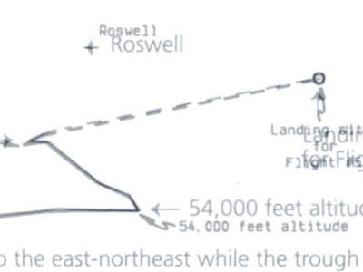
As for Rudiak's concern about the location of flight #5's landing site, there are some important points to consider. He seems to think the location of the landing site on figure 32 is accurate. I don't think it is simply because it is off the charted map. Had the actual location dictated by Crary been placed there, it would not have near the edge of the page or off it (that is if the page is in the NYU report is a perfect match in size to the original). Of course there is the problem of the accuracy of Crary's journal entry of "some 25 miles east of Roswell" (Saler, Ziegler and Moore 89). Considering that Crary's value appears to be an approximate figure, Moore moved it to a location he either felt or knew was the real location. The reason for Moore's location of the "crash site" seems to be a desire to get it correct. Recall that Moore stated that there was an oil derrick nearby. If one looks at a topographical map on terraserver it becomes somewhat clearer why he put the location where he did. There are oil wells in this location and there are none located 25 miles east of RAAF.
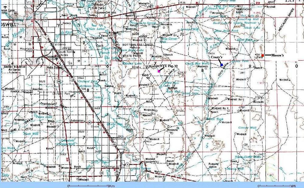
Topographical map showing the various APPROXIMATE locations for flight #5's landing
Interestingly, the location shown on figure 32 does seem to be near another oil well making one question both Crary's and Moore's locations. However, recall what Moore stated about the NYU plot and how the balloon altitude plots could not match the horizontal plot. If figure 32 were accurate, the balloons would only have drifted about 24 miles in 84 minutes. This means that the winds would only have been blowing at 17 mph in contrast with wind speeds on the ascent that were 30-50 mph. As Moore pointed out, this was unlikely. We also have the fact that Moore was at the recovery location meaning that he could substantiate the location.
October 19, 2002: After examining what Crary's journal has stated, it seems that Crary was not talking about RAAF as being "Roswell" but the town of Roswell. Moore and his group were driving east of Roswell and then had to detour to the southeast over some backroads in order to get to where the B-17 was buzzing the oil crew. If Moore's location is accurate, they would have probably gotten off the main road (380) "some 25 miles east of Roswell" near Red Tio Well. There they could take the most direct route to the landing site. When they returned back to Alamogordo, their verbal report was probably misinterpreted as to be the exact location of the debris.
October 26, 2002: After looking at Moore's location for his start points, I believe he did not use the Holloman AFB center for his launch point as the NYU project had done. Instead he apparently used the actual launch point from the north hanger. If this is so, and my calculations are correct, the landing site for flight #5 would need to be shifted north of the position shown by about 1 mile. This position also seems consistent with the direction of travel described by Moore in his book in relation to the position for NYU figure 32 on the map.
November 30, 2002: Rudiak has suggested that the 25 mile trip was to the southeast of Roswell towards the NYU Figure 32 location. This could be true but the basis he makes this upon is the use of the road going to the bottomless lakes, which was an improved road. My Conoco New Mexico map of 1947 shows that this road was mostly gravel and not much more than dirt roads. The comments in the NYU summary (along with Crary's journal) refer to the debris being "east of Roswell" and not to the southeast making it difficult to resolve the issue. Again, Moore was in contact with the B-17 and it seems that it is likely they would have been directed which dirt road to take to get to the location of the balloon debris.
December 14, 2002: Recently, I noticed that the topographic maps on line (Topowest and TopoZone) were made in the years 1949-50 for the locations in question. The oil mark near NYU Figure 32 is not an oil well but some oil tanks and a pipeline pumping station (apparently, the old pipeline ran through this area). There were no oil wells in the vicinity of Figure 32's endpoint. However, there were no oil wells in the immediate vicinity of the area marked by Professor Moore's plot either (the topographic map above comes from the 1970s). Going between the two points, I could only find two oil wells that could possibly be the source of Professor Moore's memory. There is one to the east of the Wade Ranch, which is north of the flight line about three miles to the northeast of the figure 32 position and an oil well just south of Loco Tank about 1/3 of the way between Moore's and the Crary position marked above (which is very close to the flight path plotted by Moore). Moore stated that the location of flight #5's recovery was east of the oil derrick where drilling operations were in progress. Another point to ponder is these Oil Wells are marked abandoned in the 1949 maps. This is two years after the incident so it could be that these wells were in operation at the time and then abandoned. I also attempted research online through the New Mexico Tech website using http://daihatsu.nmt.edu/Website/NMOG/viewer.htm to identify about a dozen or so oil wells along this flight path but most of them had spud dates (the date of initial drilling) much later than 1947 or the date was unavailable. None of the unavailable information wells are shown on the 1949-50 topo maps. I was also suprised that the data on the Loco tank well (or at least a well right next to the old one) indicated a recent drilling date indicating the well must have been reopened. The data is somewhat confusing at best. It seems that it is possible that the Loco tank oil well is the best candidate for the well drilling operation that flight #5 passed near (according to Moore). Of course, if this were the well, then it could validate Moore's figure. More research on the matter needs to be conducted.
Not happy with devoting one web page to this line of reasoning, Rudiak created another again focusing on Moore's apparent dastardly attempts to fudge the maps. Rudiak now focuses on Moore's original 1995 graphic displayed in Karl Pflock's book, Roswell: Inconvenient facts and the will to believe. At the bottom it reads, "The plot for Flight #5 was taken without change from Figure 32 in NYU Balloon Project Technical Report #1" (Pflock 252). Rudiak howls:
Although Moore claimed he made no changes to this plot, he actually made three, as noted on the graph in red letters below. First, he removed Roswell base from the map. Now it is no longer obvious just how close the flight actually came to the base, as in the original graphic. In its place, he put "Roswell", but now meaning Roswell town instead of Roswell base, as the original Flight #5 graphic had it. Since Roswell town was 6 miles north of the base, this has the effect of seemingly increasing the distance between Flight #5 and "Roswell". Furthermore, Moore pushed Roswell town 2-3 miles further to the west than where the Flight #11 graphic above locates it.
And finally, Moore pushed the crash site 13 miles further to the east than the original Flight #5 plot. Moore now has the distance between "Roswell" and the crash site as 31 miles, instead of 16 miles (My note: this is in contradiction to the 15 miles he stated earlier - actual computed distance is about 16.7 miles based on measured distance in photoshop for figure 32) in the original plot. By playing games with the graphic, he has also doubled the distance between "Roswell" and the crash site. (Rudiak How)
Rudiak seems to confuse the meaning of the word plot. It appears that Moore was referring to the flight #5 flightpath and not the entire graph. This leaves only one problem, the location of the crash site. Even Rudiak admits that this plot does not agree with Crary's journal. I have already pointed out that Crary's journal location (October 19: As interpreted by Rudiak) would be plotted near or off the edge of the paper! I suppose if Moore had put the exact location shown in figure 32, Rudiak would have protested that it was not an accurate representation of the flight. The end point is where it is only because Moore was being accurate with the location but Rudiak would NEVER admit this as a possibility. While Rudiak tries to paint Moore as a liar or hoaxer, he takes liberties that suggest his motives are less than honest.
November 30, 2002: The location for flight #5's landing as depicted on figure 32 is also brought into question by several interesting marks shown on the plots for flights 6 and 7, where there was recovery of some of the material. All these were given "bullseye" marks for their location (flight #7's materials were taken by passersby but they did find one balloon neck). However, flight #5 has no bullseye. Looking at flight #8, we see an "x" with an arrow pointing in the direction of travel. This seems to be similar to that on figure 32. What may be the case is that figure 32 is not a complete copy (the landing location shows and odd shaped "X" or maybe an odd arrow to a straight line) and that further notation may have been inadvertantly "cutoff" in the reproduction shown in the USAF report. When I suggested this to Rudiak he seemed highly dismissive of this possibility and continued to profess that Moore's alterring of the map was a deliberate attempt to move the location further from RAAF.
November 30, 2002: Brad Sparks in an interesting posting on UFO Updates suggested that Moore was slowly moving the postion of Roswell farther away each time he constructed a new plot. Sparks clearly stated that the distance from Roswell in 1995 was 10 miles and in 1997 was 11 miles. Even more interesting was that he described the distance from Roswell to the landing area moved from 30 to 34 miles! Measurements of both figures show this to be incorrect and that the distances remained about the same (roughly 10.5 and 31 miles). When I told Sparks his measurements were incorrect on UFO updates, he became somewhat indignant suggesting my interference was a mistake that I would regret! It seems that carefully checking values was not a concern in order to continue the accusation that Moore deliberately alterred maps. When one examines all the information, the only reason Sparks and Rudiak can accurately base this claim upon is that Moore did not mark RAAF on his maps and that his endpoint for flight #5 is not the same as figure 32. All other issues raised by Rudiak and Sparks are completely FALSE. All positions for landmarks are in accordance with the actual launch point and not due to Moore moving Roswell further to the west. Also, Moore actually did reproduce the plot for flight #5's flight path as shown in figure 32 (with the exception of the endpoint) if one compares it with Moore's map. This whole line of argument by Rudiak and Sparks is nothing but a personal attack on Moore because of his published conclusions that flight #4 was the source of the Foster Ranch debris.
November 2008 : Image showing both maps by Professor Moore being merged together. Note that Roswell for 1997 (the large cross) is slightly closer to the endpoint than the 1995 location for Roswell (small cross slight left of center of the large cross). This demonstrates the claims made by Brad Sparks that there were large differences between the 1995 and 1997 maps is a false claim. There are minor differences (as I noted on UFO updates to be a few tenths of a mile) but considering the scale of these drawings, it is not excessive enough to indicate there was an alteration done on purpose.
A Debris field on another Ranch?
Rudiak makes many models for flight #4 and has now come up with the theory that Jason Kellahin told the truth when he saw Mack Brazel and his family at a ranch along with a debris field consisting of weather balloon materials. However, Rudiak adds a twist. They weren't at the Foster Ranch. Instead, the military had found the NYU flight #4 debris sitting out near the main road of 285 running from Roswell to Vaughn. When Kellahin came looking for Brazel, he stumbled into the military's setup. Luckily, Brazel was there when Kellahin arrived because he had to be coached on what to describe. Using his flight paths, Rudiak appears to paint a convincing argument for this possibility. Again, Rudiak's theory has substantial problems he does not tell the reader.
Rudiak ignores a lot of Kellahin's testimony and his background. Kellahin was from Roswell and was at one time, the editor for the Roswell Morning Dispatch. He knew all the important people in town and talked to Sheriff Wilcox when the story broke. If he were planning on stopping by Brazel's ranch, he would have known where it was.
Rudiak brushes this information aside and makes Kellahin appear as an out-of-towner who could be easily duped. More information ignored by Rudiak is that Kellahin states he saw Brazel and his family at the ranch house. Did the military evict the true owners out of the home and who were they? Certainly, in all the interviews of people living in nearby ranches, somebody would have recalled that the Army had forced one of their neighbors out of their home. Additionally, why bother with bringing his wife and son along? Isn't it part of Roswell gospel that Mack's family was elsewhere during this time? Finally, during the interview, Kellahin suggests that he had a free hand in talking to Brazel and the personnel in the field were only a few soldiers looking around. If this were the case, it is a wonder that Brazel did not confide in Kellahin telling him there was more than met the eye in this situation. While many skeptics and pro-crash advocates alike have concluded that Kellahin's story was a confused memory, Rudiak seems to have taken him at his word-- but only the words that suit his scenario.
Of course, Rudiak doesn't mention that Marcel knew nothing of such operations being conducted. Being the 509th's intelligence officer, you would think he would have known. Also interesting is that there are no actual soldiers around to testify that they conducted such an operation despite Roswell investigators interviewing hundreds of witnesses.
Another problem with this theory is the timeline. Dubose stated 8th AF knew nothing about the event until General McMullen called him inquiring about the media reports. This could not have occurred until about 12-1PM at the earliest on July 8th. According to Rudiak, Kellahin had to have met Brazel sometime around 5-6 PM. This leaves 6 hours for the plan to evolve. Ramey had to determine what type of radar reflector was in the debris field, retrieve the appropriate sample for the photographs, age a balloon, collect the Brazel family from their home, and convey this plan to the military men who were remotely located from the base of Roswell. The ability to rapidly communicate such a plan to people in such a remote location today would be difficult. In 1947 it would be almost improbable.
I also find it interesting that Rudiak now seems to think that flight #4 existed, had radar reflectors, and landed somewhere within 30 miles of the Foster ranch.
Another Rudiak Ruse: Was Duffy really in New Jersey?
Both Captain Albert Trakowski and Colonel Marcellus Duffy are on record as reporting a telephone conversation about Duffy, who was at Wright field in Ohio, being presented some weather balloon debris to examine sometime in the summer of 1947. Apparently, it was supposed to have been from a crashed disc found in New Mexico. Duffy called Trakowski because it appeared to be materials he had worked in acquiring for the project while he was head of MOGUL in late 1946. If true, it would indicate that the debris recovered by Marcel might have been from flight #4. This part of the story is too much for Rudiak and he had to find a way to discredit it as an official effort to debunk the Roswell incident.
Rudiak's evidence is a single telegram sent to a radio station that states Duffy was not at Wright Field but New Jersey during the Roswell incident.
At 10:15 pm on July 8, roughly the same time that Col. Duffy would supposedly be viewing the flown-in debris at Wright Field, a news reporter from WKZO radio in Kalamazoo sent a telegram to the War Department in Washington. In the telegram, he wrote that military intelligence in Washington was suggesting that the saucers were radar targets used for weather observation. They proposed that he contact Col. Duffy for further information, but NOT at Wright Field. Instead, the reporter was told to contact him in Spring Lake, New Jersey! Spring Lake was only about 5 miles from Oakhurst, N.J., where the Mogul Project was headquartered and 10 miles from Fort Monmouth, where the radar targets were developed. (Trakowski said he was at Eatontown, N.J., when called, or basically at Fort Monmouth.) (Rudiak Where)
Rudiak never mentions the letter of 16 April 1947 by General Le May, which clearly states that Duffy had been transferred from his position at Watson Labs in New Jersey to be assistant chief of the Electronic Plans section at Wright field in January of 1947. Additionally, the organization chart at Watson Labs for January 1947 shows that Duffy was no longer in charge, thus confirming the letter. Then we have the obvious question that if Duffy was in New Jersey, why didn't he ask Trakowski to come over and look for himself? This indicates there was a significant distance between the two men when the call was made (something that could not be solved by a short car ride). All these points are ignored because Rudiak thinks he has the smoking gun of the telegram.
There is an obvious answer to the telegram, although Rudiak would never admit this as a distinct possibility. Somebody's card file was not up to date, and the Public Affairs Officer at the source of the telegram had sent the last known command that Duffy had been attached to, which was in New Jersey. Do you think this could never happen in a million years? Obviously you don't know the military. I recently noticed that my old command the USS Honolulu (SSN 718) had a change of command in November 2001. As of September 2002, the commanding officer listed on the ship's OFFICIAL web page was still the old captain! This was not the first time in my long Navy career that I have been exposed to out of date personnel records. In fact, every year, the Chief Petty Officer boards are inundated with packages from concerned petty officers wanting to make sure their own records are correct and up to date! I am sure things were just as bad or worse in 1947.
The telegram is intriguing, but Rudiak needs to go one step further to eliminate the SNAFU scenario. He needs to produce actual official records other than this telegram that show that Duffy was in NJ and not Wright field during the time frame of the Roswell incident.
Flight 17 and Rudiak's faded memory theory
Rudiak has suggested that Moore's recollections of a flight near Arabella and Capitan peak, NM are not of flight #4 but Flight #17 launched three months later.
Note that Flight #17 passed almost directly overhead Arabela and Bluewater, those "exotically named places" which Moore claims he only would have heard associated with Flight #4. Obviously this is just more Moore mumbo jumbo. Likewise #17 passed within only 3 miles of Capitan Peak, another landmark Moore associated exclusively with Flight #4... Obviously it is not true that Moore would only have heard of Arabela and Bluewater for Flight #4. Perhaps he simply got Flight #17 and Flight #4 confused. (Rudiak Phony)
An interesting theory but there are some possible answers. Rudiak notes that Arabella and Bluewater do not appear on this plot, thus letting Moore somewhat off the hook when he helped co-write the paper for the Journal of Metrology. However, Rudiak feels he should have heard about those places during the flight. Was it possible this was the case?
Many of these plots seem to have been created after the flight was over. The plot had to be done by hand, point to point using the data that had been obtained. During the flight, the engineers and scientists were monitoring their instruments very closely to ensure the data was being recorded accurately. They would not have time to analyze the actual values as things were happening. Additionally, these flights usually included a chase plane, which probably reported back its position. Personnel that were near the radio could hear the positions stated by the plane but there is a problem: Flight #17 had no chase plane as stated in the summary of flights because it was launched late in the evening.
As a result all the information for ground tracking came from the radio direction finding, theodolites, and radiosonde data. Without verbal reports, it was probably unlikely that the data takers and equipment monitors had little idea of the balloons actual location. However, in the case of flight #4, there was little data to gather because of the plan of using the radar reflectors to track the flight. Moore could sit back and pretty much watch the events unfold once the balloon cluster was launched. This probably included listening to the chase plane report back its position.
Again, we have Rudiak painting a certain picture that is not complete. Exactly what motivates him to do this?
Right? Wrong? Ridiculous?
Over the past decade, there have been some defections in the UFO community towards the explanation that flight #4 caused the Roswell incident. Those who honestly believe that it involved a crashed alien spaceship seem to have been deeply disturbed by this. David Rudiak is one of these individuals. He has continuously launched barrage after barrage at those supporting the NYU flight #4 theory. These barrages often include an endless series of assertions and claims that usually do not stand up under scrutiny. The same can be said for this recent series of attacks on Professor Moore and his work. What started as an honestly critical look at Moore's work, quickly degenerated into personal attacks and claims of falsifying data that just don't stand up to close examination. By bringing about potentially false charges, Rudiak has exposed himself to the same kind of charges he leveled at Moore. The misreading/misrepresentation of the data and quotes have made him look ridiculous and hypocritical. Rudiak may be right in some of his assertions and only Professor Moore can honestly answer them for him. However, his careless disregard for examining/presenting all the facts and getting some of the basic facts wrong makes his work suspect. The false accusations leveled at Moore suggests his motives were not in honest debate but to reassure those who still believed in a crashed spaceship at Roswell that NYU flight #4 could not have been the source of the debris.
October 24, 2002 Postscript: David made several comments about an email that I had sent out in September concerning some of the points I noted on this web page. I sent it out as a method of generating discussion between certain individuals about problems I had already noted in David's work. The email was forwarded by one of the recipients to another individual, who forwarded it to another group. As a result, David received a copy. Rudiak makes it seem like a clandestine email between Bruce Hutchinson and myself plotting against him. Obviously the idea that it was just between Bruce and I is false since he received a copy from another party. In this email, I had made several comments about problems I had noted with both Rudiak and Moore's work. Prior to posting this web page the questions I had voiced with Moore's plot were answered when I closely examined how he created his plot. This did not validate the plot but it did explain how it was created. As for my concerns with David's work, Rudiak has yet to satisfactorily explained his errors/omissions.
November 30, 2002: Rudiak's arguments on UFO updates were not what I would consider somebody wanting to discuss issues in a civil or scientific manner. While I tried to maintain an open/honest discussion, Rudiak resorted to name calling, ridiculing, and downplaying any possibility that he could be incorrect in his assumptions (particularly the map issues). Rather than spending weeks arguing endlessly on the matter, I felt there was no reason to continue a pointless debate. My opinion on this matter stands with what is written here on this webpage, which I will continue to update when any new information is discovered.
November 2008 : Dave Thomas' article on the "Roswell bait and switch" incited Rudiak to suggest that all of these arguments are bogus and he is the absolute authority on flight #4's flight path. He has suggested that it was extremely unlikely that flight #4 could have made it to the Foster ranch. Despite math errors present in Moore's data tables, it seems that many of his errors were, in the long run, very minor and had no significant effect on the basic profile. My examination of present day radiosonde data from the month of June over the past few years suggests that the wind shift near the tropopause is (and probably was in June 1947) variable and can shift a few thousand feet over a twenty-four hour period. The biggest issue that determines the shift in the balloon flight's path has to do with this value. Anything that shifts the rate at which the balloons rise and when they reach this critical altitude is going to shift the flight. As Professor Moore has since stated, his analysis was never meant to be a hard and fast quantitative analysis. His analysis was meant to show how the balloons might have gotten to the Foster ranch and not exactly how they did so.